Indian Magazine Applauds the Poetic Genius of a Kashmiri Bard Revering Karbala's Essence! Facilitating Arbaeen Pilgrimage: Pakistan Proposes Free Visas for Karbala-bound Travelers Are the Narrations of Karbala Reliable? A conversation with a Japanese clerk Sheikh Ibrahim Swada Interview with an American Orientalist Unity in Faith: Iraq and Pakistan Set the Stage for Pilgrim-Friendly Policies in Karbala and Najaf Pictures: Museum of the Holy Shrine of Imam Hussein How Iraqi people became the best hosts in history? - Part II How Iraqi people became the best hosts in history - Part I The center holds a seminar On the unseen dimensions of the personality of Imam Hussein, peace be upon him (Part One) Mr. Abdul Amir Al-Quraishi receives the delegation of the Iranian Arbaeen Committee From the sea to Al-Hussein sacred slaughter place Roofing the streets of the old city (views) A delegation from Karbala Center for Studies and Research visits the Media Department at Al-Hussaini Holy Shrine Karbala: Tarateel Sajjadiyya Festival With Pictures … Arbaeen pilgrims walking from the southernmost point of Iraq Publication of the eleventh issue of (The Week) newsletter Karbala theater produced by history and represented by reality (scenes) The committees of the International Conference for the Arbaeen visitation hold their session in preparation for the conference A meeting on ideological linguistic vocabulary
Karbala's Atlas / Geogrphical Location
01:39 PM | 2020-12-01 2098
جانب من تشيع الشهيد زكي غنام
تحميل الصورة

Administrative Borders and the Area of ​​the Karbala District and Its Annexes In 1876 AD

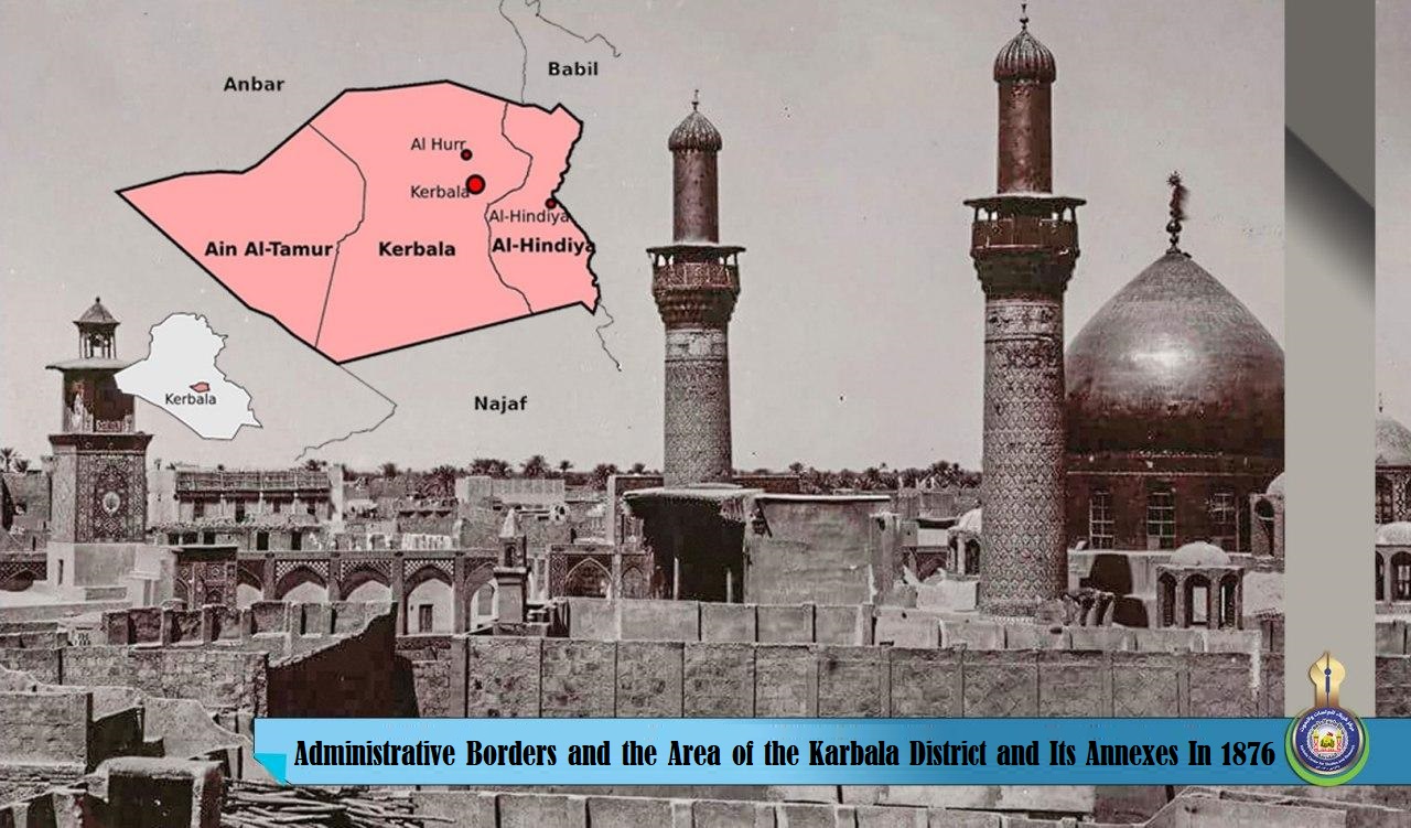
The Karbala district is located within the state of Baghdad during the Ottoman era, it was bordered on the northwest by Al-Dulaim sub-district, on the north by the Al-Kadhimiya sub-district, on the east and southeast by the Diwaniyah district, and from the west and southwest by Badiat Al-Sham desert.


As for the administrative borders of the Najaf district, it is bordered on the north side by the Karbala district, on the east side by Al-Hindiya district, and Al-Shamiya sub-district, one of Al-Diwaniyah sub-districts, and from the south and west with Al-Shamiya desert.


Whereas, the northern administrative borders of Al-Hindiya were the Karbala district, from the east, the Hilla district, the south and southeast, Al-Shamiya sub-district, and from the south and west the Najaf district.
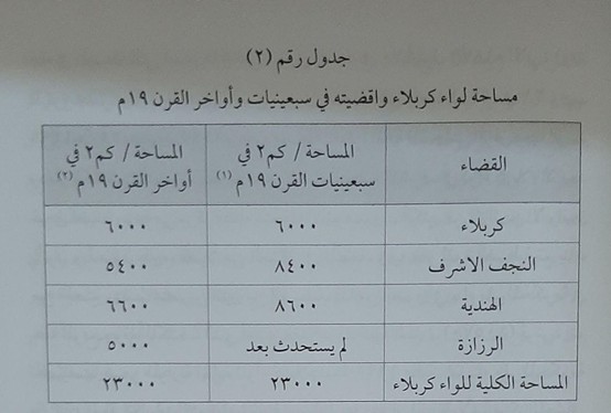
 

As for the area of ​​the Karbala district and its administrative annexes, it was between the seventies and the end of the nineteenth century AD, as demonstrated in (Fig. 1).

It is noticed on the aforementioned figure that the establishment of Al-Razazah sub-district was at the expense of the Al-Najaf and Al-Hindiya districts, as an areas of ​​(3000) and (2000) km2 were deducted from Al-Najaf and al-Hindiya districts respectively in order to form this subdistrict.


Source:
Mawsueat Karbala Al-Hadharia "Karbala Civilizational Encyclopedia". 

A publication of Karbala Center for Studies and Research

The Historical Ax, Department of Modern and Contemporary History.

[Vol. 2, Pg. 473-475].


Facebook Facebook Twitter Messenger Messenger WhatsApp Telegram Viber Email