
Karbala governorate consists of several administrative units which the Karbala district center is the administrative center of them as follows:
Karbala District Center
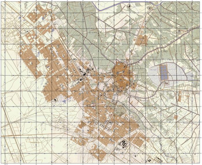
The Karbala District Center is the city center of Karbala. The city of Karbala was famous for its religious function since its founding in the year 61 Hijri around the holy shrine of Imam Hussein and his brother Al-Abbas "peace be upon them" after the tragic battle of "Al-Taff". The district center has formerly occupied a large area west of the Euphrates that extends toward the town of "Al-Musaiyab" in the holy city of Najaf. The district center relates from the north to the "Dulaim" district and relates to the "Kadhimain" district from the north and toward "Al-Hindiyah" district from the east and connects with the border of Najaf from the south and with the desert of "Shamiyah" from the west.
More than (35) agricultural municipality were affiliated to this district such as Bada'at Aisha, Umaisha, Al-Assafiyah, Bada'at Aswad, the greater Awaira, Al-Ibrahimeya, Abu Gardan and others. The city of Karbala is an administrative center for the whole "Sanjak" or "the Ottoman governorate". It is managed internally as a municipality and as a headquarter of its executive ruler. It also had an infantry regiment based within its border permanently.
The city has occupied during its long history, different urban areas that started with less than 1 km2 in the early beginnings of its foundation to reach more than (25 km2) after the World War One, as it occupies now an urban area of more than (67 km2) plus the non-urban lands belonging to the district such as the town of "Al-Hurr" to reach more than (2397 km2). The city was able through different time and urban stages to form its contemporary urban identity, while its population structure has witnessed a major development with more than (511,434) citizens in 2007 equal to (58%) of the population size of the province within its three residential sectors (The old city sector, Al-Haidariya and Al-Jazeera sector) with a group of residential neighborhoods that numbered with more than 60 residential neighborhood.
Al-Husseiniya Town
It is one of the oldest administrative municipalities of the Karbala district. It is located about 20 kilometers north-eastern of the city of Karbala. It has an area of about (337 km2). It was formed of agricultural districts and villages that benefited from its geographical potentials, especially the water availability and soil fertility that made it well known for various agricultural activities practiced by the population to this day. The town overlooks the Husseiniya river, which is one of the largest irrigation channels in Iraq and is branching from the right bank of the Euphrates River at Al-Musaiyab town. The historical sources mention that the Husseiniya river was digged by the Ottoman Sultan Suleiman I when he took Baghdad as a headquarter of his government in 1544 AD. The administrative center has witnessed a change in its geographic location, when the Taff district was the administrative center of the area until the 1970s, it has been later moved to Al-Utaishi area along the river with a distance of less than 10 km due to the lack of urban areas suitable for urban expansion in the first place, the agricultural status was predominant on this area as it was the main economic activity of its population, which made the urban areas do not constitute only a few of it. The urban area occupied about (294,78) acres within the limits of its basic plan, with a population of (128521) in 2009.
Al-Hurr Town
Al-Hurr is located in the north-western part of the city of Karbala at a distance of 2 km. It has an area of about 24 km2. This area has been changed in its administrative borders several times, as well as a change in its administrative affiliated areas with Karbala district center and others. It was mentioned in the 1957 census that this area is one of the affiliates of Al-Husseiniya district and was remained in this case until the 1965 census then it was segregated in the 1977 census.
The district center is a small town with a population of only 512 people. In the 1987 census, it was merged with the Karbala district center and became independent as a municipality belonging to the holy city of Karbala. This municipality was established around the shrine of the great companion "Al-Hurr Ibn Yazid al-Riahi" who was martyred in the tragic battle of Karbala with Imam Hussein (pbuh). His shrine is the first of its kind that was built outside the walls of Karbala after the construction of the two holy shrines of Imam Hussein and his brother Al-Abbas. This shrine was built in the era of Sultan "Bahma Agha Khan" in 1325 Hijri. The construction process of Al-Hurr was a major attraction factor for the population around it. The district center represents an important urban gathering today as it witnessed a high population concentration over the years. The city consists of four main residential sectors (The center sector, Al-Taqqa sector, Al-Yarmouk and Al-Abed sector), and includes more than (15) residential neighborhood that the distribution of population varies among them depending on the availability of basic services on the one hand and their diversity regarding the urban side on the other.
Al-Hindiya District
The Hindiya district is the second largest district in Karbala in terms of area. The city center of Hindiya was grown as a small settlement on a series of heights south of the current city, this area was thensubmerged by water and after the establishing of the Hindiya channel in 1793 AD, the course of water was fixed in a steady course, which helped the Arab tribes to settle in it and practicing agriculture. In 1840 the Hindiya district was approved and occupied the area named currently as "Twaireej" as center of the district under the name of "Hindiya" and linked to one area which is "Al-Jadwal Al-Gharbi" or the "Western Stream".
The first municipality was founded in the district at 1875 that had a municipal council and is considered one of the first agricultural districts that was run majorly by the British authority. It was divided during the British occupation into four sectors which were Al-Jadwal Al-Gharbi, Um Ruwaya, Abu Gharaq and Al-Kifil. Most of the district's areas are located on the banks of the Hindiya river starting from the south of the city of Musayyib and ending north of Kufa. The area of the district is about 157 km2 and during the Ottoman rule of Iraq, especially during the era of the governor Medhat Pasha, the administrative degree of Karbala was raised to the rank of "Executive Province". The Karbala city border has remained included with the city center and its adjacent areas and was expanded later to include the district of Najaf.
The Hindiya remained at times as affiliate to Hilla city once and sometimes to Karbala administratively, while the population of the district has reached according the 1965 census about (111930) citizens when it was affiliated with Hilla city. Today, the district of Hindiya is divided into two areas: "Al-Jadwal Al-Gharbi" and Al-Khairat with all of its rural and remote areas. The district of Hindiya has become an administrative and service center for the inhabitants of these areas as it expanded along sides of the river to occupy an urban area of more than (831,992) hectares. The Hindiya district is followed by two towns:
"Al-Jadwal Al-Gharbi" Town
This town is located in the east of the city of Hindiya with a distance of 25 km. The town was developed under a royal management in 1930 with an area of 187 km2. The area was established in the form of scattered houses, which are watered by a small stream called Um Natrara, which a subsidiary river from the Euphrates in its western bank and that's why "Al-Jadwal Al-Gharbi" was known as "The Western Stream" . In 1987, the population of the town reached about (35519) citizens, which increased to (72309), which were distributed by (5210) in the urban neighborhoods and (67099) in the rural areas according to 2005 census.
Al-Khairat Town
This town is located to the south east of the city of Karbala and south of the district of Hindiya and one of the latest towns of the city of Hindiya in terms of development. Historically, this area has undergone many changes regarding the administrative side with the district of Hindiya, in 1977, it was an independent administrative unit. It was attached to district in 1987 and at the beginning of 1997, it was separated from the district of Hindiya. The city center of Al-Khairat was mentioned in the 1997 census as the smallest administrative unit in the province in terms of population size. Its population has reached about (54757) citizens in 1997, it was increased in 2005 to more than (50702) citizens, which were distributed by (553) in the urban neighborhoods and (50149) in the rural areas within residential neighborhoods no more than five neighborhoods.
Ain al-Tamr Town
The center city of Ain al-Tamr "The Oasis of Dates" is located in the western part of Karbala by (70 km). The town was established by a presidential decree in 1976 with an area of 1956 km2. The city center of Ain al-Tamr is one of the oldest historical sites in the region and has a great importance due to its geographical location at the intersection of many commercial roads and convoys transportation between Iraq and Syria on the one hand and the with Arabian Peninsula on the other.
Yacout al-Hamawi mentioned in his dictionary that Ain al-Tamr is an old town located on the edge of the desert, and was conquered by the Muslims during the succession of Abu Bakr al-Siddiq in 12 Hijri. The city was called by this name due to its huge amounts of palm that was cultivated and exported to the neighboring areas, some historians believe that the history of Ain al-Tamr town dates back to the pre-Islamic period and that it dates back to the pre-birth of Jesus Christ (pbuh) because of the many evidences and artifacts that support these believes such as the shrines scattered around the town and the craters of the basements with bones of the dead people from those periods especially from the western village of "Shathatha", which was destroyed by the water recession as well as the disease and epidemics that attacked its people in the past periods of time.
The current town of Ain Al-Tamr is located between magnitude (9°32"-50°32") north and longitude (10°43"-43°46") east, bounded from the east by Karbala city center and from the rest of the other areas by Anbar province. The desert landscape represents the topographical scene. The region relies on a unique hydrological system of water represented by water springs and groundwater. The area contains more than 36 water springs, most of which were drained except for (10) that is still used by the population which are the Ain Al-Suda, Judaida, Al-Zarqa, Umm al-Kawani, Al-Hamra, Umm Tair, Umm Al-Sharifa, Al-Saada and Al-Sayb. The region was and still an important commercial center for Bedouins who migrate with their livestock between the borders and deserts.
The population of the town has reached (24558) in 2007, and the town center has witnessed a great development in the urban and service areas, so it became an administrative, service and commercial center for its residents and the residents of nearby agricultural villages such as Shafatha, Shuaib and others. The agricultural areas constitute a large extension of the town areas, which numbered by more than (28) agricultural areas, most notably Al-Bahwa, Al Ain, Northern Umm Rumaila, Southern Umm Rumaila, Eastern Umm Rumaila, Al-Malih, Al-Alwa and other, beside the agriculture villages that depends on ground waters and considered as natural pastures for grazing sheep and camels, many of which are: Faydha Maliha, Faydha Al-Kaseer, Fayyadh Al-Shakhat and other remote areas.